According to forecasts, up to 50 mm of precipitation could fall between 16 and 20 August. There is a possibility of snow in mountainous areas and the greatest intensity is expected to occur in the Metropolitan region.
The water crisis experienced in various regions of the country has been a topic of conversation for the agricultural world in recent years, and the situation has worsened even more during this winter season, with a significant deficit of rainfall, comparable even to what was experienced in 1998-99, when there was electrical rationing, and to what happened in the 1960s.
The Maule region, which together with O'Higgins, accounts for 80 percent of the total hectares of cherry trees in the country, has a deficit of 60% in rainfall compared to the normal for now. Only 300 mm have fallen, while in a normal year the figure is 800 mm, and in a deficient year 500 mm. To this we must add the low volume of the reservoirs, in addition to the high temperatures expected for spring.
In the midst of the analysis of a series of measures that will mainly affect irrigation flows during this season, two major frontal systems will affect the central and southern areas of the country, which, although they will not solve the serious water crisis, will leave 50 mm of precipitation and possible snowfall in mountainous areas.
“We will have two precipitation events, which will be separate but consecutive; one that will arrive first on Monday and will affect the Biobío region to the south, moving to the central zone, and the other that will be a little more intense and will be concentrated from the Coquimbo region to the south. This is what we see today, we are quite early, this can vary, that is why it is important to keep updating the forecast. This frontal system, according to what I can see today in the different models, is the most important of the winter, it comes with a greater amount of water concentrated in a short time, accompanied by low temperatures and snow,” detailed meteorologist Michelle Adam.
The specialist assured Smartcherry.cl that between 30 and 50 mm of rain are expected and that the greatest intensity of the weather event has moved from Maule to the Metropolitan region. The frontal systems will present zero isotherm at low levels, which indicates that it will snow and not rain in the mountain range, ruling out concerns about avalanches or landslides, and generating snow accumulation, so useful for the spring and summer months.
“This is the rain of hope for fruit growing, nobody expected that we could have this amount of rain at this time, also with the focus that in the high mountain range snow can accumulate, because it is the reservoir that we need for the season and that, obviously, the reservoirs are filled; this rain allows us, in addition, to have a good filling of ponds, considering that the “soil ponds” are a water reservoir for the season, where the roots can be hydrated, they can ensure their entire physiological process in favor of the development of the plant in spring.”, said Carlos Tapia, specialist advisor in cherry production and Technical Director of Avium.
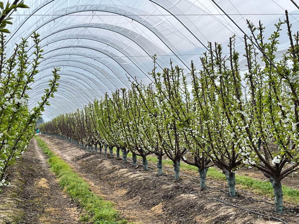
Weather events, in terms of rainfall, are quite beneficial for fruit growing, considering the water shortage of the current season, both for mature orchards and for new plantations.
“This allows the new plantations that are being developed at this time to also have a good root system, since these rains also allow the hydration of the new species placed in the soil and that the plant can develop normally in the first stage; and finally, I also think that it is the rain that we were waiting for for everything that is the control of winter weeds and control of residual weeds, so that the herbicides can be incorporated into the soil and do a more efficient job to keep the orchards cleaner in spring.”, Tapia explained.
After the storm… comes the calm?
The frontal system that will bring numerous benefits for fruit growing could also bring with it a typical concern of the season after rainfall: frost.
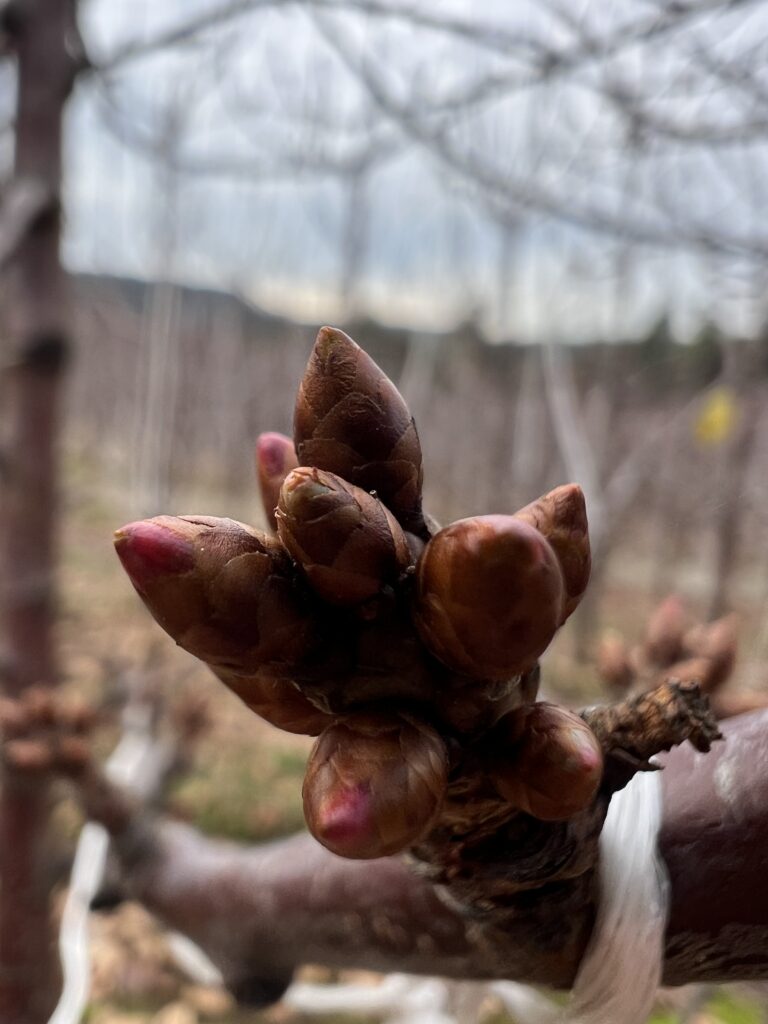
“When we are about to begin the active phenology of this species that we are so passionate about, the classic concerns always begin, mainly about what the risk of frost means at the end of winter and spring, which clearly regulate our productive potential. We are on the verge of visualizing the most advanced states of phenology at the end of winter, I am referring mainly to the state of breaking of bracts or swollen bud, and that makes us pay attention to some important events and mainly the concern lies in the whole issue of risk due to frost. If we review the literature, in the last decade it has been reported that the sensitivity in terms of risks of cold damage is in the measure that the phenology evolves, from swollen bud to petal fall or jacket fall,” explained Carlos Tapia, Technical Director of Avium.
According to weather forecasts, low temperatures will be expected next week; although it is necessary to monitor as the days go by to see how the weather phenomenon evolves, so far a scenario is expected that could be detrimental to agriculture.
“It is very complex because we see a lot of rain in a short time and then it gets cold again. We have had a winter with very extreme temperatures, many frosts before time and higher temperatures than we should have, but we are going to return to the morning cold, we are going to return to the frosts,” warned meteorologist Michelle Adam.
According to the monitoring carried out by the Avium technical team, regarding the current phenological states between Rancagua and Chillán, the plants in their different varieties, mostly present dormant buds, however possible frost events after the rains, could cause serious damage to the fruit centers that at that time show more advanced phenological states.
A worrying situation, since the greatest risk and damage from frost occurs early in the season, from swollen buds to exposed branches. Although there is also a risk in recently set fruit or sheath fall, this phenological state normally occurs in the second week of October, when the probability of frost is much lower than at this time of year.
“Definitely the most important moment and the one in which we get most nervous is from swollen bud to exposed bunch, and that is where we have to become aware of the possibility of controlling frosts. This year we have seen in early areas and in warm areas an unexpected advance of the phenological states based on a couple of antecedents, such as the early use of dormancy breakers to be able to take advantage of these warm areas, which has been accentuated by a rise in temperatures that the Metropolitan region and O'Higgins had the last week of July, which also makes the phenology advance. In these areas, the concern regarding the management of frost control should have started on August 1st,” said Carlos Tapia, a specialist advisor in cherry cultivation.
The recommendation is, if available, to use an active frost control system from bud swell until October 5-10 in the central area (until the sheath falls off); in areas not so advanced, frost control should be carried out from August 15, regardless of the forecast intensity or probability of the events, in order to protect the productive potential of the orchards. In addition, the necessary adjustments should be made to the phytosanitary programs close to the phenological stage of bud swell.